What about the early non-European
people of what is now Perkasie?
 Lenape Portrait Purported to be Nutimus
The first people of what is now Perkasie were the Lenni Lenape per the 1859 map of Bucks County “Pocasie.” Reference: Lenape of Bucks County, Davis.
Archaeologists estimate indigenous people lived in this area between 12,000-18,000 years before the Europeans arrived in the New World. These Lenape spoke a dialect of the Algonquian language called Unami. Some of the rocks found at the Meng Preserve show “mortar” indentations that may have been created by the Lenape to grind nuts and grains against the hard stone.” Reference: Trappe Reference Historical Society- Henry Muhlenberg House
Reference: The Meng Preserve, in Schwenksville
2. Early European Explorers and the Lenape
In 1524, while exploring the coast, Giovanni da Verrazzano and his crew came into contact with Native Americans living on the Northeast coast. In New York Bay, the group encountered the Lenape in about 30 Lenape canoes and observed what he deemed to be a large lake, really the entrance to the Hudson River. Reference: Morison, Samuel Eliot, The European Discovery of America: The Northern Voyages. New York: Oxford University Press, 1971, p. 490.
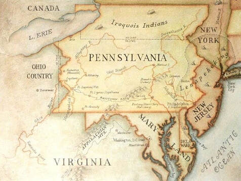
Traditional Lenape lands, the Lenapehoking, was a large territory that encompassed the Delaware and Lehigh Valley regions of eastern Pennsylvania and New Jersey from the north bank of the Lehigh River along the west bank of the Delaware River into Delaware and the Delaware Bay.
The waterways of Southeastern Pennsylvania were important navigation and migration routes. The Perkiomen Creek feeds the Schuylkill River which continues into the Delaware River, Delaware Bay and into the Atlantic Ocean. Reference: Perkiomen Watershed.org
The Perkiomen name is from Lenape term Pakihm Unk (pronounced for Pah Keym Unk), which means "cranberry place" in English.
- 1. Ancient Peoples
Archaeologists estimate indigenous people lived in this area between 12,000-18,000 years before the Europeans arrived in the New World. These Lenape spoke a dialect of the Algonquian language called Unami. Some of the rocks found at the Meng Preserve show “mortar” indentations that may have been created by the Lenape to grind nuts and grains against the hard stone.” Reference: Trappe Reference Historical Society- Henry Muhlenberg House
Reference: The Meng Preserve, in Schwenksville
2. Early European Explorers and the Lenape
In 1524, while exploring the coast, Giovanni da Verrazzano and his crew came into contact with Native Americans living on the Northeast coast. In New York Bay, the group encountered the Lenape in about 30 Lenape canoes and observed what he deemed to be a large lake, really the entrance to the Hudson River. Reference: Morison, Samuel Eliot, The European Discovery of America: The Northern Voyages. New York: Oxford University Press, 1971, p. 490.
Traditional Lenape lands, the Lenapehoking, was a large territory that encompassed the Delaware and Lehigh Valley regions of eastern Pennsylvania and New Jersey from the north bank of the Lehigh River along the west bank of the Delaware River into Delaware and the Delaware Bay.
The waterways of Southeastern Pennsylvania were important navigation and migration routes. The Perkiomen Creek feeds the Schuylkill River which continues into the Delaware River, Delaware Bay and into the Atlantic Ocean. Reference: Perkiomen Watershed.org
The Perkiomen name is from Lenape term Pakihm Unk (pronounced for Pah Keym Unk), which means "cranberry place" in English.
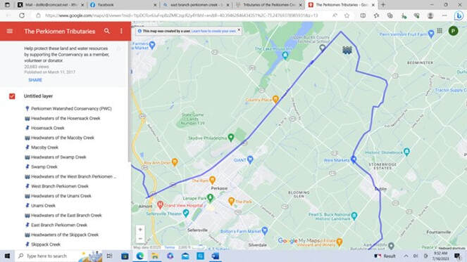 The Perkiomen Tributaries - Google My Maps
3. The Lenape as “Original People”
“The indigenous people who inhabited the land that became Philadelphia were the Lenape (also Lenni Lenape; their English moniker was “Delaware”); they were displaced by Quakers and other religious minorities that settled the Commonwealth of Pennsylvania in the late 17th and 18th centuries.”
William Warner also came to a land inhabited by the Lenape or "Original People," West Philadelphia’s first natives. They were a nomadic people belonging to the Algonquian language family. Important tribes within this language group also included the Ojibwa, Blackfoot, and Shawnee. Reference: Walter Licht, Mark Frazier Lloyd, J.M. Duffin, & Mary D. McConaghy.
4. Unami: People who Live Down-River
The Lenape were divided into three bands or sub-tribes: the Minsi or Munsee, “People of the Stone Country” inhabited the northern part of Pennsylvania, the Unami, “People Who Live Down-River” inhabited the central region of Pennsylvania, and the Unalachtigo, "People Who Live by the Ocean,” inhabited the southern area of Pennsylvania.
The Lenape who inhabited the land that became Philadelphia spoke the Unami dialect.
Reference: West Philadelphia Collaborative History - The Original People and Their Land: The Lenape, Pre-History to the 18th Century (upenn.edu)
Pennsbury Manor April 2023- Doll image
|
Pennsbury Manor April 2023- Doll image
|
Pennsbury Manor April 2023- Doll image
|
5. Along the East Branch of the Perkiomen Creek
The East Branch Perkiomen Creek, also known as Branch Creek, is 24.5 miles long running from Perkasie Borough, Bucks County through Earlington, Franconia and Salford, Montgomery County before joining the Perkiomen Creek in Schwenksville. Additionally, Indian Creek (6 miles long), Pleasant Spring Creek, Mill Creek and Vaughn Run all run into the East Branch. Reference: Perkiomen Watershed.org.
The Lenni Lenape where in this area before the Europeans settlers but they did not see themselves as owning this land. The concept of land ownership did not exist for them. “The Lenape regarded the land as like air and water, the common shared heritage of all.” Reference: Plumstead Historical Society
6. King Charles II land grant to Sir William Penn
In 1681, King Charles II granted a large piece of his North American land holdings along the North Atlantic Ocean coast to William Penn to offset debts he owed Penn's father, the admiral and politician Sir William Penn. The land included the present-day states of Pennsylvania and Delaware.
By 1682, Penn left England for what was then British America for the first Pennsylvania General Assembly. These early colonists pledged allegiance to Penn as their new proprietor. It was about that time, that William Penn first met the Lenape. Reference: visit to Pennsbury Manor- film
In William Penn's 1684 written account of the people he encountered along the Perkiomen, he recounted the Lenape as a peaceful tribe, christened as the "Delaware" by early Europeans. There were none of the massacres such as those that took place as near Berks County and close to Harrisburg. In fact, some of the Lenape married with the settlers. Reference: "Schwenksville history buff digging into past to unearth P. Valley secrets." Valley History, Chris Kraft interview 1999.
7. Settlement of Bucks County
Bucks County’s oldest settlements were concentrated in what is now Lower Bucks County. The frontier moved north from the Schuylkill River to the branches of the Perkiomen Creek through the northern part of Philadelphia. This area was known as the “Great Swamp,” today known as the townships of Milford, Richland, East and West Rockhill, and adjacent sections of Lehigh and Montgomery Counties centrally located around Quakertown.
In the 18th century the term swamp referred to “a low rich area of land, heavily forested and somewhat too damp for cultivation unless drained.” Upon clearing the land, the settlers found productive and fertile land.
The first surveys of land were made in 1703. Provincial Secretary James Logan instructed surveyors Thomas Fairman and David Powel to lay out several tracts. The first tract, was 10,000 acres which later became known as “Manor of Richland.” A manor is
defined as an estate or district leased to tenants, especially one granted by royal charter, in this case, William Penn. The land belonging to William Penn was land occupied by tenants who were interested in securing religious freedom and avoiding religious persecution.
The southern and central portions of the Great Swamp were settled first by the Society of Friends and by 1715 became members with the Quakers. Not until 1747-48 were the township boundaries determined.
Meanwhile the Scotch-Irish settlers, predominantly Presbyterian, settlers moved out of Philadelphia to the northeast into the central and upper parts of Bucks County. Welsh Baptists settled in Montgomeryville in 1719.
German settlers came to the branches of the Perkiomen Creek and settled in Richland and Milford and areas north. Richland requested the boundaries of their township be more clearly defined with Hilltown Township. This definition then resulted in a gap of “unorganized territory marked as “Servants Township” documented in the 1724 map of Hilltown. This same area is recorded in 1739 as Freetown and by 1764 the area was named Rockhill Township. Reference: Bucks County History p 45+, 64-67, 81 and - Creation of Townships/ Rockhills/Perkasie
The Lenni Lenape were the first people to have resided in this area as documented by fieldstone rocks marking the gravesites of Native Americans. Tohickon Evangelical Church, founded in 1743 and Jerusalem Church founded in 1826 both have these such gravesites. Reference: Images of America East and West Rockhill Townships
8. The Walking Purchase
Indian Chief Tamanend and other leaders met with William Penn to negotiate the acquisition of land. One of Penn’s Manors, the Manor of Perkasie now encompasses Perkasie, Sellersville, East and West Rockhill Township and Hilltown.
The Walking Purchase of 1737 was the most detrimental to the relationship with the Lenni Lenape and the Delaware. William Penn’s heirs fraudulent interactions resulted in the infamous land grant Walking Purchase. Reference: Albert Cook Myers, William Penn: His Own Account of the Lenni Lenape or Delaware Indians, 1683, Moylan, Pa: A.C. Myers, 1937 p. 85-86
This alienation resulted in the tribes joining the French against the English colonies in Pennsylvania.
9. Richard Penn’s Manor of Perkasie
This partition of Richard Penn’s Manor of Perkasie in 1735 followed the establishment of a bishop-district church in the Great Swamp. Reference: Chapter 5- Reference 78 Petition for Roads (76-146) and p 96 and p. 138.
“Berkosen” was known as the Perkasie Church and is now known as the Blooming Glen Mennonite Church. This is consistent with the establishment of the Perkasie Post Office with the railroad in Perkasie Borough and did result in the name change to Blooming Glen. The British last march in Bucks County in June of 1778, brought armies from Valley Forge East to protect New York. (Reference: Schwenfelder presentation to Perkasie Historical Society- September 2021 conversation with Mennonite Heritage Center)
Jacob Stout owned approximately 250 acres of land at the East Branch of the Perkiomen Creek and Pleasant Spring Creek.
Reference: Stout Family Land Deeds in the Perkasie Historical Society Collection.
Stout’s movement of goods and livestock to the area of the ravine in the Perkasie Park is reported in October of 1886 (Central News Oct 14, 1886) during the Revolutionary War. Much of what is now South Perkasie was first settled by Jacob Groff. South Perkasie was Annexed to Perkasie May 8th, 1899. (Central News May 11, 1899)
Is Landis Ridge a Lenape lookout? The Walking Purchase Historical Marker is located at the intersection of Route 563 and Route 413. Route 563 is also known as Ridge Road as it follows the higher altitude of the 3 parallel roads in what is Perkasie today. (Ridge Road, Fifth Street and Constitution Avenue- along Perkasie's Lenape Park)
 Lenape Nation of Pennsylvania (lenape-nation.org)
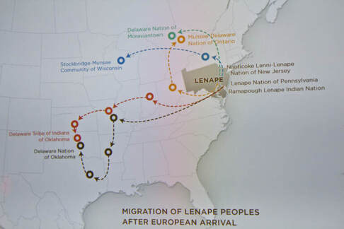
10. Lenape displaced from their homelands
The Lenape seek Pa. recognition, and a return home - WHYY
11. Lenape in Genealogy research
- Carole Clark of Hatfield Historical Society shared in her genealogy research, she confirmed there was a Lenape trading post in Hatfield on her family’s homestead. (personal interview July 15, 2023)
- Indentured and servants also appeared in census and tax records.
12. Lenape Today in Perkasie?
In "LaVO: Connecting Perkasie and Sellersville, Lake Lenape is a greenbelt wonder born in the Great Depression." It is noted that Lake Lenape Park: Lake Lenape Park, named for indigenous Native Americans, illustrates how two communities can come together in a time of national economic peril to find a means to restore civic pride and lay a foundation for prosperity. The idea was to create a landscaped, 122-acre park connecting Sellersville with Perkasie by restoring a dam, re-watering a former lake and otherwise revitalizing a despoiled section of the East Branch of the Perkiomen flowing through both towns.
Lake Lenape a wonder born during Great Depression (phillyburbs.com)
|
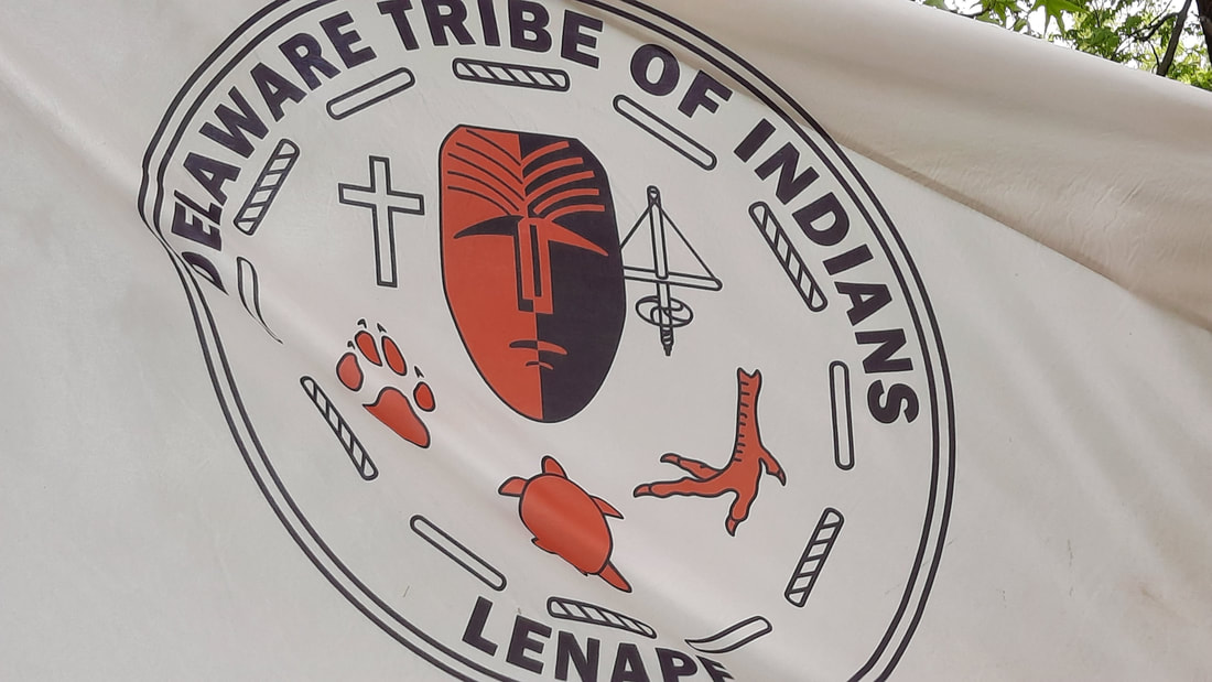
Official website of the Delaware Tribe of Indians:
https://delawaretribe.org/
|
A 501 (c) (3) Non -Profit organization, Lenape Nation of Pennsylvania, not currently affiliated with the Delaware Tribe of Indians can be found at the following link: Lenape Nation of Pennsylvania (lenape-nation.org) |
Doll, Cook, Murga